
In the Summer of 2009 wildfires swept across Black Mountain south of Sorrento. Varying estimates state up to 1020 hectares were burned. This dramatically changed the watershed’s ability to absorb the annual spring run-off.
In the Spring of 2011 new waterways formed on Notch Hill cutting gullies 15-20 feet deep. Houses were flooded, roads washed out, and the water system in Notch Hill was contaminated. Almost every year since then the under-sized culverts on Notch Hill have had to be dug out by excavators for about a month to clear the debris and gravel coming off the mountain as a result of the fire. The Ministry of Transportation and Infrastructure knows about this, but they have chosen to continue spending money on an emergency basis rather than fix the culvert system.

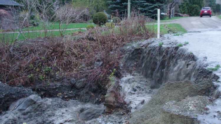
In the Spring of 2017 massive erosion occurred in Newsome Creek below Highway 1. Elevated water levels undercut the banks below homes, workshops and garages. Trees fell into the ravine, and created a dangerous situation for residents and visitors to the area. Emergency Services BC (EMBC) requisitioned a study that recommended hands-on work be done to prevent further damage to the banks. No action was taken by any governmental body.
In the Spring of 2018 more erosion occurred in Newsome Creek below Highway 1. More trees fell into the ravine, and banks were undercut even further. On May 2 an Evacuation Alert was placed on 11 homes. EMBC quickly funded another study focusing on the geo-technical aspects of the creek below HIghway 1. A month later a Danger Tree Report was also done as trees continued to fall into the ravine putting peoples’ safety in jeopardy.
In the Fall of 2018 the results of the study were released to the homeowners, and presented to the general public at a Community Stakeholders meeting at Sorrento Memorial Hall. The study recommended an assessment be done in the watershed above HIghway 1, as well as a feasibility study below Highway 1 to determine how the gully could be stabilized.
In January of 2019 CSRD and EMBC matched funding, each paying 50% of the cost for an engineer’s assessment which will focus on the area below Highway 1 where erosion is threatening homes and workshops. The purpose of the assessment is to create an “engineer approved work plan” so Phase 2 can begin. Phase 2 is doing the actual work that the engineers recommend, which will require another wave of funding which NCWAG has not yet secured.
In June of 2019 a work plan was created. The company outlined several things that can be done to fix the creek. With a plan we were able to make specific requests to government agencies. Read the Plan.
2019 to 2020 – Numerous attempts were made to get funding through federal and provincial grants, but none were issued. As a group we continued to lobby the provincial government, but were repeatedly turned away.
COVID and post-COVID – Throughout the lockdown we were unable to meet as a group, and progress stalled on local efforts to get something done about the creek.